Satpara lake with green water and shape of heart lies on the road to Deosai plain, Sakardu, Pakistan.This beautiful lake is also very famouse for Trout hunting.Water of Desai is stored here naturly.In these days Govt of Pakistan conveting it into Dame. Due to this project Sakurdu city and srounding will be able to got enough electric power.Thanks for sharing and your time. With best regards...Nadeem Khawar
Tuesday, 12 July 2011
satpara lake The beautiful place
satpara lake
Satpara lake with green water and shape of heart lies on the road to Deosai plain, Sakardu, Pakistan.This beautiful lake is also very famouse for Trout hunting.Water of Desai is stored here naturly.In these days Govt of Pakistan conveting it into Dame. Due to this project Sakurdu city and srounding will be able to got enough electric power.Thanks for sharing and your time. With best regards...Nadeem Khawar


Satpara lake with green water and shape of heart lies on the road to Deosai plain, Sakardu, Pakistan.This beautiful lake is also very famouse for Trout hunting.Water of Desai is stored here naturly.In these days Govt of Pakistan conveting it into Dame. Due to this project Sakurdu city and srounding will be able to got enough electric power.Thanks for sharing and your time. With best regards...Nadeem Khawar
Monday, 11 July 2011
The Biggest Glaciers in pakistan
THE LARGEST LAND OF GLACIERS
·
by Dr. Nayyar Hashmey
·
In about 1978, the Indian Army mounted an expedition to Teram Kangri peaks (in the Siachen area on the China border and just east of a line drawn due north from NJ9842) as a precursor-exercise (a camouflage to occupy the area by force). The first public mention of a possible conflict situation was an article by Joydeep Sircar in The Telegraph newspaper of Calcutta in 1982, reprinted as “Oropolitics” in the Alpine Journal, London, in 1984. India launched an operation on 13 April, 1984. The Indian Army and the Indian Air Force went into the glacier region. Pakistan army quickly responded with troop deployments and what followed was literally a race to the top.
CURRENT SITUATION
Ever since then, the Indian Army occupies the high altitude side of the Siachen Glacier and the three main passes of the Saltoro Ridge immediately west of the glacier, Sia La, Biafond La, and Gyong La, thus holding onto the advantage of high ground. However, its tactical advantage by contrast demands a heavy toll in terms of money and human loss. Gyong La (Pass) itself is at 35-10-29N, 77-04-15E; that high point is controlled by India. Pakistan controls the glacial valley five kilometers southwest of Gyong La.
Though Pakistani soldiers have waged a valiant struggle to get up to the crest of the Saltoro Ridge, the Indians resist to come down and abandon their strategic high posts. In 2003 a ceasefire went into effect. Even before then, every year more solders were killed because of severe weather than enemy firing. The two sides have lost more than 2,000 personnel primarily due to frostbite, avalanches and other complications.
WHO OWNS SIACHEN
The glacier is well inside Pakistani territory. But India’s strategic want to keep an eye and a possibility to seek vigilance over Pakistan’s strategic route to China (the Karakorum Highway) in 1982 it sent a training expedition to Antarctica to train under “Siachen Glacier Like” conditions. Then in April 1984, it conducted its Operation Meghdoot’, and invaded Pakistani territory.
Since the glacier is not physically connected to India (there is no natural ground routes connecting India and Siachen Glacier), therefore, it used its Air Force to drop all of its forces at Siachen and still to this day uses helicopters and aircrafts to transport supplies, food and soldiers.
Historically-geographically-and factually this third pole on earth is well Inside Pakistan where Pakistanis are confronting the Indians who have a force 5 times their size. However, India in the process is paying a heavy price. According to a book on the War on Siachen, 50% of Indian soldiers, who make back alive, suffer from permanent mental retardation, not to mention amputations and other terrible things that Indian soldiers have to go through.
The Majestic range of Karakoram in Northern Pakistan has the honor of having World’s largest glaciers outside north and south poles. The picture here is among one of them taken in the extreme summer month.
Pakistan: Nanga Parbat 9th Highest Peak in the World


Air force :Air Commodore MM ALAM has a world record of shoting down 5 Indian planes in less than a Minute


Pakistan : The Roof Top of the World
Pakistan the land of grand mountain ranges, a land that holds 4 out of 14 most highest peaks in the world. K2 the second highest mountain in the world with all it’s grandeur symbolizing the pride and strength of the people of Pakistan.
Aisa’s Highest Railway Station Kan Mehtarzai
Hunza is said to be a place ” Where Time Stops and Fairy Treads“, Kalash and Chitral are the natural wonders of the world where poetic verses find their inspirations from the beauty and elegance of high peak mountains, lush green fields and the fragrant breeze singing across the poplar trees. Some of the places which are not highlighted by the media but still due to their magnitude find their places on the World record books are ; Aisa’s Highest Railway Station Kan Mehtarzai [2] that is located 2240 meters above sea level near Quetta.


Hunza is said to be a place ” Where Time Stops and Fairy Treads“, Kalash and Chitral are the natural wonders of the world where poetic verses find their inspirations from the beauty and elegance of high peak mountains, lush green fields and the fragrant breeze singing across the poplar trees. Some of the places which are not highlighted by the media but still due to their magnitude find their places on the World record books are ; Aisa’s Highest Railway Station Kan Mehtarzai [2] that is located 2240 meters above sea level near Quetta.
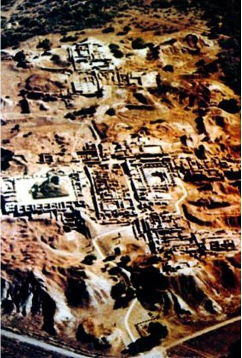
The land of oldest Civilization : Indus Valley and Mohenjo-Daro
Moenjodaro is the province of Sindh, Pakistan and archeology trace back it exitence 5000 years ago. It provides an earliest instance of exemplary form of town planning and community organization and found to be as one of the oldest cities known today. It is said to be the pilgrimage of ancient ruins. The splendor of Indus Valley civilization spread over a thousand mile from the high peak snowy mountains of Kashmir to the glittering sand dunes facing the Arabian Sea. One of the oldest known civilization that flourished in the Indus river Basin embraced within its fold almost the entire country now known as Pakistan.


Moenjodaro is the province of Sindh, Pakistan and archeology trace back it exitence 5000 years ago. It provides an earliest instance of exemplary form of town planning and community organization and found to be as one of the oldest cities known today. It is said to be the pilgrimage of ancient ruins. The splendor of Indus Valley civilization spread over a thousand mile from the high peak snowy mountains of Kashmir to the glittering sand dunes facing the Arabian Sea. One of the oldest known civilization that flourished in the Indus river Basin embraced within its fold almost the entire country now known as Pakistan.

Subscribe to:
Posts (Atom)