Sunday, 17 July 2011

Grand Canyon Skywalk


The Grand Canyon Skywalk is a horseshoe shaped cantilever bridge and tourist attraction inArizona near the Colorado River on the edge of a side canyon in the Grand Canyon West area in the main canyon.[1] USGS topographic maps show the elevation at the Skywalk's location as 4,770 ft (1,450 m) and the elevation of the Colorado River in the base of the canyon as 1,160 ft (350 m), and they show that the height of the precisely vertical drop directly under the skywalk is between 500 ft (150 m) and 800 ft (240 m).[2]
Commissioned and owned by the Hualapai Indian tribe, it was unveiled March 20, 2007, and opened to the general public on March 28, 2007. It is accessed via the Grand Canyon West Airport terminal or a 120-mile (190 km) drive from Las Vegas, which includes a 10-mile stretch of dirt road which is currently under development. The Skywalk is east of Meadview and north of Peach Springs withKingman being the closest major city.
David Jin, an entrepreneur who had been involved with tourism and the Hualapai Nation for some time, had the idea of extending a platform out over the edge of the Grand Canyon. With the help of architect Mark Ross Johnson, that idea evolved into a rectangular walkway and eventually the "U"-shaped walkway that has now been constructed.
The overall Skywalk width is 65 feet (20 m). The Skywalk length extending out from the post supports closest to the canyon wall is 70 feet. The outer and inner 32-inch-wide (810 mm) by 72-inch-deep (1,800 mm) bridge box beams are supported by eight 32-by-32-inch (810 × 810 mm) box posts having four posts on each side of the visitor’s center, once completed. The eight posts are anchored in pairs into four large concrete footings that are in turn anchored to the bedrock by ninety-six 212-inch-diameter (64 mm) DYWIDAG (acronym pronounced Doo-Wee-Dag) high strength steel threaded rod rock anchors grouted 46 feet deep into the rock.
The deck of the Skywalk has been made with four layers of Saint-Gobain Diamant low iron glass with DuPont SentryGlas interlayer. Deck width is 10 feet 2 inches (3.10 m). The Skywalk glass railings were made with the same glass as the deck, but fewer layers (two) bent to follow the walkway’s curvature. The glass railings are 5 feet 2 inches (1.57 m) tall and have been designed for high wind pressures.
The Skywalk deck was designed for a 100-pound-per-square-foot live load along with code required seismic and wind forces. It can support the equivalent of 71 loaded Boeing 747 aircraft or an 8.0 magnitude earthquake within 50 miles (80 km).[3] Fine-tuning of the project occurred after a wind loading and pedestrian induced vibration analysis. Two tuned mass dampers were installed inside the outer box beam as well as one inside the inner box beam at the furthest extension of the Skywalk to reduce pedestrian footfall vibration. The walkway could carry 822 people that weigh 200 pounds (91 kg) each without overstress, but maximum occupancy at one time is 120 people.
The Skywalk was assembled on top of the canyon wall in line with its final placement and moved into final position by a jack and roll rig. The Skywalk infrastructure itself weighs a little over 1,000,000 pounds (450,000 kg) without counterweights but including the tuned mass dampers, railing hardware, glass rails, glass deck and steel box beams. At the time of roll-out, the Skywalk weighed approximately 1.6 million pounds. The process was completed in two days.
The Skywalk glass itself was manufactured and imported from Saint-Gobain Deutsche Glas (Kinon in Aachen) and Glas Döring in Berlin, Germany.
Structural design was provided by Lochsa Engineering out of Las Vegas, Nevada. Contractor is Executive Construction Management also located in Las Vegas, Nevada. Foundation design was aided by John Peck (Geologist), Aaron Hastings, P.E. of Arroyo Engineering Consultants, Inc. (Geotechnical Engineer), DJ Scheffler, Inc and Crux Subsurface, Inc.
Astronauts Buzz Aldrin and John Herrington attended the opening ceremony on March 20, 2007.
Grand Canyon Skywalk

The Dachstein Glacier

The Dachstein Glacier


Do whatever you want - that's the motto on the Dachstein. 
And the Dachstein Glacier really has something to offer every visitor. 
The Dachstein is unique in the Alps, not just due to its exposed location, but because of the wealth of activities it has to offer.


Dachstein Sky Walk

The latest attraction on the Dachstein is the Ice Palace


Delve into the depths of the Dachstein glacier! The Ice Palace is a unique attraction in Austria and is open daily. The Dachstein Ice Palace allows visitors an insight into the hidden world of a glacier - just three minutes from the Dachstein cable car mountain station, open all year round whatever the weather.

On a tour deep inside the glacier which has many spacious corners, visitors can discover attractions, such as the Thronsaal (throne hall), the Kristalldom (crystal dome) or the blauer Salon (blue salon). The impressive portal of columns and the detailed ornaments were directly carved out of the glacier ice over several weeks by Chinese ice artists. The Ice Palace took more than a year to build and the final result is a fascinating, mystic experience of ice, light and sound. The throne hall is especially impressive. The portal of the Greek Acropolis was immortalised here in ice. Even the floor in the corridors is made from ice. The origin of a glacier is explained to visitors at the entrance in a simple and understandable way.


Dachstein Eispalast Dachstein Eispalast


The Dachstein Sky Walk - the most spectacular viewing platform in the Alps


The Dachstein Sky Walk is formally enthroned at 2,700 m above sea-level, high up on the 250 m vertical rock face of the Hunerkogel.
A 360 degree panorama allows the visitor a view of Slovenia in the south to the Czech Republic in the north. This "balcony of the Alps" is distinctly higher than the platforms of the Niagara Falls or the Iguazu waterfalls in Brasil. 


Dachstein Skywalk


All year round ski area and paradise for cross country skiing on the Dachstein


The Dachstein Glacier offers ideal pistes for beginner and intermediate alpine skiers as well as those wanting to warm up for the winter season. Nordic skiers can enjoy 18 km of well-groomed cross country trails. 


Sonnenuntergang am Dachstein Langlaufen am Dachteingletscher


Glacier hike to the Dachsteinwarte (2.741 m)


This winter hike leads over a prepared glacier footpath the the highest refuge in the Dachstein range (2.748 m) with a fabulous view of the Dachstein-Südwand.


Sonnenuntergang am Dachstein Wandern am Dachstein


The ski touring paradise on the Dachstein


"Austria's National Ski Tour" also starts on the Dachstein: The Dachstein Crossing. 
15 further tours are available in the area!


Am Gipfel des Dachsteins

Saturday, 16 July 2011

Adalaj Vav, Gujrat

Adalaj Vav, Gujrat


Location : 18 Kms North of Ahmedabad, Gujarat. Meaning : Step Well.
Built By : Ruda, Wife Of Vaghela Chief Virsinh.
Built In : 15/16th Century AD.
Adalaj is a village 18 kms to the north of Ahmedabad . The ‘Vav’ (step-well) at Adalaj derives its name from the lady patron, Ruda, wife of the Vaghela chief, Virsinh; who built it in the 15th or 16th century AD. The ‘Vav’, laid out in the north-south direction, the step well with the well in the north and the entrance in the south, has a total extent of 75.3 meters. It is the only major monument of its kind, having three entrance stairs leading to the stepped hall. These three entrances assemble in the first storey, underground, in a huge square platform. The platform has an octagonal opening on the top.
The Structure:
The platform rests on 16 pillars, eight on the corners, and two in front of each Adalaj Vav, Adalaj Vav historical, Adalaj Vav travel, Adalaj Vav tourism, Adalaj Vav Historical Placemain side. Four built-in shrines, with doors, windows and balconies, mark the four corners of the platform. The stepped corridor begins from this square platform. The corridor is entirely surrounded by a one-meter high ramparts wall with a rounded topping. It descends with four pavilion towers for five storeys. The walls of the ‘Vav’ are veritable showcases of sculptures and ornamentation. The sculptures range from a king sitting on a stool under a parasol, to erotic scenes; and from ladies churning buttermilk to dancing girls. The frames of the doors around the entrances of the twisting staircases to the octagonal shaft are surrounded by a ‘parikrama’, which is an enlarged version of the frames around the niches. Stringcourses running along the sidewalls embellish all parts of the structure, sometimes dividing the wall into horizontal sections. They also come into view on the walls of the octagonal shaft, depicting floral or leaf patterns, or rows of animals.
Adalaj18.jpg
Adalaj19.jpg
Adalaj13.jpg
Adalaj23.jpg
Adalaj31.jpg

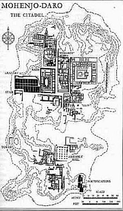
Mohenjo-Daro An Ancient Indus Valley Metropolis

Mohenjo-Daro

The name of Mohenjo-daro is widely recognized as one of the most important early cities of South Asia and the Indus Civilization  and yet most publications rarely provide more than a cursory overview of this important site.Mohenjodaro City
There are several different spellings of the site name and in this article we have chosen to use the most common form, Mohenjo-daro (the Mound of Mohen or Mohan), though other spellings are equally valid: Mohanjo-daro (Mound of Mohan =Krishna), Moenjo-daro (Mound of the Dead), Mohenjo-daro, Mohenjodaro or even Mohen-jo-daro. Many publications still state that Mohenjo-daro is located in India (presumably referring to ancient India), but since the creation of Pakistan in 1947, the site has been under the protection of the Department of Archaeology and Museums, Government of Pakistan. 

Discovery and Major Excavations

Mohenjo-daro was discovered in 1922 by R. D. Banerji, an officer of the Archaeological Survey of India, two years after major excavations had begun at Harappa, some 590 km to the north. Large-scale excavations were carried out at the site under the direction of John Marshall, K. N. Dikshit, Ernest Mackay, and numerous other directors through the 1930s.

Although the earlier excavations were not conducted using stratigraphic approaches or with the types of recording techniques employed by modern archaeologists they did produce a remarkable amount of information that is still being studied by scholars today (see the Mohenjo-daro Bibliography).

The last major excavation project at the site was carried out by the late Dr. G. F. Dales in 1964-65, after which excavations were banned due to the problems of conserving the exposed structures from weathering.

Since 1964-65 only salvage excavation, surface surveys and conservation projects have been allowed at the site. Most of these salvage operations and conservation projects have been conducted by Pakistani archaeologists and conservators.

In the 1980s extensive architectural documentation, combined with detailed surface surveys, surface scraping and probing was done by German and Italian survey teams led by Dr. Michael Jansen (RWTH) and Dr. Maurizio Tosi (IsMEO).

Mohenjo-daro Mound
The most extensive recent work at the site has focused on attempts at conservation of the standing structures undertaken by UNESCO in collaboration with the Department of Archaeology and Museums, as well as various foreign consultants.

Details of the most recent salvage excavations and conservation are found in obscure journals or reports that are not readily available to the public, but are listed in the Bibliography for those interested in searching them out.


Wednesday, 13 July 2011

saif ul malook (Kaghan)

Amazing colours of  my beloved, beautiful pakistan..... Crystal clear waters of  Satpara lake, 8 kms from Sakardu The inter-connected Biafo and Hispar glaciers form the longest glacial system in the world outside the polar area and combined length is about 116 kilometers. It is also linking the Baltistan and Hunza Valley and cutting through the Karakuram Range. The climax of this trek (HisperPass) 5150m, at the conjunction of the Biafo (60 Km) and HisperGlacier, offers incredible view of peaks and glacier valleys


Tuesday, 12 July 2011

Ansoo Lake in Pakistan


Ansoo Lake is a high-altitude lake (elevation 13,575 feet or 4,137 metres) in the Kaghan Valleyin the Mansehra District of the Khyber-Pakhtunkhwa province of Pakistan. It is near Malika Parbat in the Himalayan range.
This lake can be reached by two different routes. First one is short but steeper trek from Saiful Mulook Lake. It takes more than 12 hours for a round trip to Ansoo lake starting from lake Saiful Mulook. The trek is covered with snow in most parts of the year. The best time to trek is from July 10 to August 15. The optimal time to set off for the lake from Saiful Mulook is around 06:00 in the morning. Horses can also be hired from the Lake Saiful Mulook along with a guide who will take you to Ansoo Lake. It costs almost PKR 1200-1500 per horse and PKR 1000 additional for the guide but one still has to walk more than 35% of the distance by himself. This trek can be further divided into two part. First half, which is towards Saiful Malook, is valley along the river and it goes up to Malika Parbat base camp. Second half is steeper starting from Malika Parbat base camp and ends with Ansoo Lake. This part is all about climbing on the mountain.
Second trek to reach Ansoo Lake starts from the village Mahandri, which is 40 km south toNaran Village, and it goes through Manoor Gali and Kach Gali. This trek takes at least three days of 12 hour trekking to get to Ansoo Lake. Steepness of this trek may be the same as of other one but travel in the valley is lot more. This gives an opportunity to camp along the rivers, in jungles, on the top of mountains and in abandoned towns.
Both of above mentioned treks run in opposite direction from Ansoo lake and are connected via mountains top forming half circle 300–400 feet above the lake waters. From this altitude, there is an amazing vista of lake on one side and top of Malika Parbat and beautiful skyline of high altitude mountains covered with snow on the other side. There is no risk free way to reach lake waters because it lies in the crater with steep, snow covered walls. There is no apparent drainage of lake water and no one ever tried to explore it because of its dangerous approach and limited resources in that area.
The name "Ansoo" comes from its tear-like shape (the Urdu word Ansoo means teardrop). This lake also resembles Human Eye with central ice land resembling Iris of Human Eye and a ridge resembling Eyebrow becoming even more prominent when ice melts on the Eyebrow in summers. This ridge was partially destroyed in 2005 Kashmir earthquake.
The lake is said to have been discovered in 1993 by Pakistan Air Force Pilots who were flying low in this area. Earlier, the lake was not even known to the locals.[citation needed]
There is no place to stay at Ansoo Lake. Some people may camp on the top of extremely cold and windy mountains at their own risk.
Aansoo Lake - Naran, Northern Areas

Upper Kachura Lake


Upper Kachura Lake is of clear water and has a depth of 70 metres (230 ft). [1] In summer it has a temperature of 15 °C (59 °F). In winter the surface is frozen solid. The upper Indus River flows nearby at a lower elevation.
The beauty of the Upper Kachura Lake is almost untampered and mostly unexplored by travelers, due to lack of infrastructure owing to its rough terrain The area is has a rich flora of the Western Himalayan subalpine conifer forests ecoregion, and also known for its wild apricot -Prunus armeniaca orchards. Recreation activities at Upper Kachura Lake include hiking, trout fishing, and Himalaya mountaineering.
Kachura Lake

satpara lake The beautiful place

satpara lake
Satpara lake with green water and shape of heart lies on the road to Deosai plain, Sakardu, Pakistan.This beautiful lake is also very famouse for Trout hunting.Water of Desai is stored here naturly.In these days Govt of Pakistan conveting it into Dame. Due to this project Sakurdu city and srounding will be able to got enough electric power.Thanks for sharing and your time. With best regards...Nadeem Khawar
Satpara Lake - Sakardu, Northern Areas
Chillam - Sakardu, Northern Areas

Sheosar Lake - Sakardu, Northern Areas